Up & Down with a Bang, the Empire State
Up & Down with a Bang, the Empire State
July 31st-August 2nd
Leaving Vermont by way of seeing Ethan Allen’s Homestead, back though Burlington, to Hwy. 2W, back up the Grand Isle, pass South Hero, than North Hero, named in memory of the Revolutionary dead, then pass Funny Franks giant outdoor art/junk/art/some bizarre stuff, arranged by Frank, only a for few minutes, there is also Tinker’s Barn for another fun stop, then I stop at the Champlain Statue, and find Saint Anne’s Chapel, established in the mid 1600’s, and Mass is going on, silent respect for the religon, yet I am not a Catholic anymore, I buy a small book on St. Francis, my confirmation name, more on that later, then pass Alburg, nice small town, used the library, interesting folks, good people.
Then onward I drive over into New York on to Rt. 115 to 9B South pass Chazy, founded in 1804, pass the Largest McIntosh Orchard in the World, and Conroy’s Organic Beef, gas is higher $3.15
In NY, great views of the lake looking east, quickly into Plattsburgh, though medium-size town congestion unto Rt. 3S, up slowly, climbing into the Adirondacks, facts about the Adirondacks: Algonquian and Mohawk Indians used the Adirondacks for hunting and travel, but they had no settlements in the area. Samuel de Champlain sailed up the Saint Lawrence and Rivière des Iroquois near what would become Ticonderoga on Lake Champlain in 1609, and thus may have been the first European to encounter the Adirondacks. Jesuit missionaries and French trappers were among the first Europeans to visit the region, as early as 1642.
Part of the French and Indian War (1754-1763) was played out on the edge of the Adirondacks. The British built Fort William Henry on the south end of Lake George in 1755; the French countered by building Fort Carillon on the north end, which was renamed, Fort Ticonderoga after it was captured by the British. In 1757, French General Montcalm captured Fort William Henry.
At the end of the 18th century rich iron deposits were discovered in the Champlain Valley, precipitating land clearing, settlement and mining in that area, and the building of furnaces and forges. A growing demand for timber pushed loggers deeper into the wilderness. Millions of pine, spruce, and hemlock logs were cut and floated down the area's many rivers to mills built on the edges. Logging continued slowly but steadily into the interior of the mountains throughout the 19th century and farm communities developed in many of the river valleys.
The area wasn't formally named the Adirondacks until 1837; English map from 1761 labels it simply "Deer Hunting Country." Serious exploration of the interior did not occur until after 1870; the headwaters of the Hudson River at Lake Tear of the Clouds near Mount Marcy were not discovered until more than fifty years after the discovery of the headwaters of the Columbia River in the Canadian Rockies of British Columbia.
Launched by the Adirondack Explorer, a bi-monthly news magazine covering the Adirondack Park, the campaign has identified three distinct parts of the Saranac Lakes Wild Forest for action. If successful, another 2 percent of Adirondack waters will become more peaceful, and more consistent with the state’s wilderness mandate for the park,
now crossing the Saranac River, Black Brook, Franklin, Sugar Bush, and a right on Rt. 30N to Fish Pond Sate Park.
Back at camp, a pleasant evening reading my little book on Saint Francis, a good man, also reading a book of Appalachian stories, I have a nice small fire, some light drizzle, a few beers, I am good, then off to sleep in my little tent, then Bang! Lighting all around, then Thunder, three hours of it, my last wishes spoken quietly, God’s bowling three hundred, I was in this storm, it’s all around me, Crack lighting , Boom, moments later, Boom, hey its been a good life, the next morning, I am Alive, the camp is silent, we were all silent, cleaning up, in awe of last night and in quiet rejoice we made it, weary I am I am, a great area, lots of canoeing and kayaking, a paradise in the lake and river country, these North County Woods, here at Fish Pond State Park, when the decision was made to keep Little Tupper Lake motorless several years ago, motorboat and jet ski enthusiasts complained bitterly that their sport was once again being shut out in the Adirondack Park. In fact, only about 5 percent of the surface water in the park is currently off limits to speed boats. That will change slightly, however, if a new Quiet Waters Campaign succeeds.
Then on to the next day quickly pack, a wet & tired wanderer I be, into Tubber Lake for a fine breakfast and hot coffee at Owl’s Head, I meet a fellow born in 1943 Hungary, lives in Canada now, we are at the counter, it's the best seat in the house, then back on the road south on Rt. 30 to Blue Mountain Lake, not the right turn in town, still south on Rt. 30, not Rt. 28, its ok, tired, things work out, pass Indian Lake, to Rt. 8, less expensive property here, then on to Itaca by way of Rome. You figure it out, I’m poopy and exhausted from last night.
Downtown Itaca closes up early, some happenings, a quiet steakhouse for a New York Steak and Baked Potato and a couple of Seneca Micro-Brews, talkin’ to locals, good conversasion about the local economy, then somesleep, priceless.
Utica, New York, like many industrial towns and cities in the northeastern Rust Belt, Utica has experienced a major reduction in manufacturing activity in the past several decades, and is in serious financial straits; many public services have been curtailed to save money. The Erie Canal (currently part of the New York State Canal System) is a canal in New York State, United States, that runs from the Hudson River to Lake Erie, connecting the Great Lakes with the Atlantic Ocean. Although the canal was first proposed in 1699, it was not until 1798 that the Niagara Canal Company was incorporated and commenced preparations for building. The first section of canal was completed in 1819, and the entire canal was opened on October 26, 1825. It was 363 miles long, 40 feet wide and 4 feet deep. There were 83 locks along the canal, each 90 feet by 15 feet. Maximum canal-boat displacement was 75 tons. The Erie Canal was the first transportation route faster than carts pulled by draft animals between the Eastern Seaboard of the United States and the western interior, and cut transport costs into what was then wilderness by about 95%. The Canal resulted in a massive population surge in western New York, and opened regions further west to increased settlement. The Erie Canal was also called "Clintons Ditch" before it was finished being built.
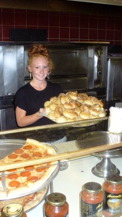
Leaving the next day back to Rome, all roads lead there you know, its hot already, more storms coming, take Rt.49W, pass Floyd, then 69W, pas Fort Stanwix, Erie Village, now farmland into Camden, stop at Avicollies for Pepperoni Pizza, great, and some fresh Garlic Knots
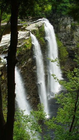
 , wonderful, get some for later, “Buon Appetito”, back to farm country to the Salmon River and a hike to Salmon Falls, the Salmon River is located in Oswego County, New York at the eastern end of Lake Ontario. It is considered to be the best place in the Northeast United states for salmon angling because of its high diversity of trophy-size salmon and trout including Chinook salmon, Coho salmon , steelhead trout, Atlantic salmon, and brown trout, great for the local economy in the Fall, to the falls take CR 22, leaving take CR22 to Orwell, left on Rt. 2, to Pulaski, then Rt.2A to 13W, pass Fresh Country Corn, CR5W to Rt.3S to Port Ontario, crossing the Salmon river at the mouth, Rt.104B along Lake Ontario, then Rt.104W, fruit trees here, apples, cherries, peaches, lots of orchards, Rt.104A though Fair Haven, its 95 degrees and humid, hard rain hits on to Sodus Bay, and the lighthouse,
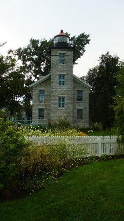 a Sodus, On May 26, 1824, Congress appropriated $4,500.00 for construction of a lighthouse to be located on Great Sodus Bay, New York. Located in north-central Wayne County is the Town of Sodus. Bordered by Lake Ontario, the town is rich with history, patterned with blossoming fruit orchards and dotted with cobblestone architecture.
  Heluva Good Cheesemade here, truth is, the Heluva Good name dates back to 1925 when Perry Messinger, our founder, began making wedges of homemade washed curd cheese in the basement of the A.B. Williams Store in Sodus, N.Y. (For those who ask "Where the heck is Sodus?," it's on the south shore of Lake Ontario, just east of Rochester.) Messinger sold a little, but mostly did it as a hobby. Then, one day, a traveling salesman stopped in and sampled a wedge. Upon tasting it, he declared, "That's a hell of a good cheese." At that moment, Messinger knew he had something very special. A new company, and a new name, were born, then back on the Seaway Trial to Niagara, then Rt.104W to Rochester, city traffic, pass Kodak Park, then Rt. 18W/104 to Lake Ontario Parkway, beautiful way to stay close to the lake, need gas, not much here, take CR272 to Morton, then Rt. 18W, back into orchards and dairy farms, kinda flat here, old homesteads as I get closer to Niagara Falls and Buffalo area, back to Rt. 104W to Interstate I-190 for five miles to a cheap hotel on Niagara Falls Blvd, when traveling, stop at the Information Centers, they have discount coupons for room, mine only $29, rest needed, another wicked storm, this time I watch from under the awning on this cheap motel, Pop, there goes the TV reception.
Lake Champlain, Vermont to Fish Pond State Park, New York
58.7mpg/ 155.5 miles traveled
Fish Pond to Utica, New York
59.6 mpg/ 173.4 miles traveled
Utica to Niagara Falls, New York
60.1 mpg/ 303.9 miles traveled
Time to check tire pressure!!!
another beer: southern tier from lakewood NY
phin & matt's extraordinary ale,good while watching a lighting storm!!!
posted by oregonman at 12:27 PM
![]()

0 Comments:
Post a Comment
<< Home