Time to Go West!
11,231 Miles, Time to Go West!Nice drive out of Banger, after pushing out the blog, if I can write at night, until visibility and the words all meld together. The next morning I clean up the mess, try to edit, get pictures ready, copy & paste, highlight, upload pictures, then post the thing, then run. Am I getting the story? There are lots of other notes, thoughts, viewpoints and pictures, when I get back home, I hope to add those to this story of travel. Please read though all misspellings, misunderstandings or confusion I may cause, on the fly blogging, at its finest... Traveling back, going west is liberating, I will be traveling to totally unknown areas of the country, and I have never explored the Northern Route. Can I find home-cooked meals, not ones from the back of a truck in the northern regions.
Leaving on Route 2W, out of Banger, I will be on and off this road until I get to Washington State.
Watched the movie Grizzly Man, it’s a fascinating story of Timothy Threadway, he lived with the Grizzly Bears for 13 summers, watching, studying, filming, bonding, then trying to be a bear if he could, he pushed the envelope, love him or not, the thing became bigger than him, and he put himself in greater and greater danger, greater the risks, greater the reward, he was eaten, as well as his girlfriend by a Grizzly, he died doing what he thought was best, you be the judge, what makes us do the things we do, wander, explore, indulge in our own cleverness.
Western Maine, Oxford County, they just had a Bicentennial in 2005, America’s only Oxford County, evidence of native inhabitants date back 11,000 years, later, at the time of the settlers, the Pigwackets lived along the Saco River, and the Amarascoggins lived along the Androscoggins River, with waterways and trials being by-ways between them both.

Then early settlers carved farms out of pine, fir and spruce lowlands and hardwoods uplands, early farmers brought in oxen to do the heavy clearing. Most homes were one room log cabins with oil-soaked paper windows. Soon wide spread stonewalls skirted paths from fields being cleared, of all too common granite rock, and there are rocks everywhere, Rocks & Roots.
Early settlers relied on each other, utilizing special skills each had to trade for goods and supplies. A tough live, life in New England, with its heavy snows and cold winters to hot humid summers.
Onward, though Newport , by a Wal-mart, Always low prices, Skowhegan, following the Kennebec River, then Farmington, back into the hills, pass the Purple Haze Gift Shop, even a town called Mexico, to Newry, a quick tour up Rt. 26N to the Sunday River Covered Bridge,
 lots of covered bridges though out New England, then back to the Sunday River Brewery for a Black Beer BBQ Burger with bacon, cheddar cheese and Black Bear Porter BBQ Sauce and a 420 IPA brew, the best meal I have had leaving the coast. Their beers: Sunsplash Golden Ale, 4.5%, Sunday R. Lager, hops and malt from Germany, 420 IPA at 5.75%, then Black Bear Porter, malty & hoppy with coffee overtones 6.0%, they also serve Knuckle Ball Bock from Portland, Maine, not bad, and the food, great burgers and lots of BBQ selections, Pulled Pork, Beef Brisket, ½ Chickens, Baby Back Ribs, Beef Ribs, St. Louis Ribs with a Mustard Base Sauce, and a Bourbon Marinated Sirloin steak, serious stuff.
Then on to New Hampshire and the White Mountains, turn South on Rt. 16, this is ski country, some ones else's vacation paradise, I drive pass the Auto tour of Mount Washington, I maybe back, $20 a pop to drive to the top, stopped at a store for beer, ice and firewood, 200 beers to choice from, $8.99 for a mixed pack: Anchor Liberty Ale, Smuttynose Portsmouth Lager, Sea Dog Porter, Black Fly Stout, Sierra Nevada Porter and anew one, Tuckerman Pale Ale with English & Belgium Malt, four domestic Hops, then Dry Hopped, so the beer can finish in the bottle. Not Bad for this weary traveler.
Down to Glen, take Rt. 302 to Crawford Notch State Park, its raining, thunder and lighting, too.
Later, time for a quick evening hike to Ripley Falls, a nice 100ft. It runs more down the rocks then falls over them, still nice, quiet time sitting on a rock by my lonesome in he woods.
At the bottom of the road, a fellow wanderer, a bearded hiker named Jeremy aka Orangeman, he left March 10, and he is hiking the Appalachian Trail solo, you can find his journey on www.trailjournals.com, search for “Orangeman”, he needed a ride to a bunk some 3 miles up the road, my camping stuff is out of the car, nice to be able to give him a ride.
Back to Camp, raining again, while reading in the car, I hear my ice crest outside making noise, no more than 5 feet away is a Black Bear, no food, just beer in the cooler, my photo journalism teacher is going to be pissed, no picture of Jeremy, no picture of the bear, instead I get out, wave my hands, remember show no fear, these words from Grizzly Man, the bear goes behind a bush, just looks at me, leave me and my beer alone, will he be back?
62.9 mpg/ 199.3 miles traveled

Nice Morning, cloudy, no rain, drive back down Rt. 302 to 16N to Mt. Washington, $20, up the 6288 foot mountain, Skate loves mountain roads, the Native Abenaki people had two names Agiocochock “Place of the Great Storm Spirit” and Kadoak Wadjo “ the Hidden One”, some of the first settlers to go up around 1840 were Ethan Allan Crawford, he even guided Daniel Webster up, then in 1853 the Tip Top House was built, it still stands, they feed people and there were bunks, too. A Carriage house was built in 1861 and
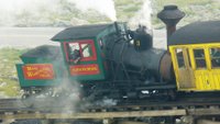
 the World’s first Cog railroad came up in 1869, some grades are at 34 degrees, it was called “Railway to the Moon”.
 Mt. Washington can also boast to be the oldest hiking trial in America 1819, they also do weather research up here, on April 12th, 1934 the highest wind ever recorder at 231 mph, a low pressure system over the NE had actually passed though, then backed out, the system circulated counterclockwise in the Northern Hemisphere, and with this storm, a big wind came from the SE creating this big wind, barometric pressure was 22.82, lowest recorded on the summit.
 A great ride up and down, no mountain to view, I am in the clouds, no guard rails, tight corners, and everyone lived today.
 The Cog Railroad was fun to watch, come up and descend, they use coal, let the pressure build, and then off it goes. Or down or up.
 They used to take mail, and even a newspaper, some time ago, on a Slideboard or “Devil’s Shingle” down, using a handbrake to slow it down, some folks went to fast and would fly off the tracks, some 3 deaths and several injuries later. No more Slideboard. Only pictures remain.
Off the mountain back up Rt.16 to Rt. 2 then Rt.16N, Berlin, lumber mills, I travel along the Androscoggin River, in days past, Boom Piers were constructed in the river, man-made islands used to secure a chain of boom logs, these islands still exist, shattered up the river for miles, then on to bouncy Rt. 110 to loop the top of the White Mountains, into timber country, then take Rt. 3 to Lancaster and Rt. 2 again into Vermont, gentle rolling hills, farms, cows, maple syrup, though St. Johnsbury, then on to Rt. 15 pass Waldren and the Cabot Creamery, Wardwick and the Buffalo Mt. CO-OP to Hyde Park, then down Rt. 100S though Stowe, a hopping arty place, to the Ben& Jerry’s Ice Factory, on to Waterford, turn right on to Rt. 2 again, a few miles, camping at Little River State Park at Mount Mansfield.
56.6/217.4 miles traveled

Little River State Park, this is a hidden gem, in the hills next to the park, there are old ruins of the early settlers, a history walk here is a journey though time, miles of stone walls, cemeteries, cellar holes and orchards give evidence of life over a 180 years ago.

Joseph Ricker broke ground on Ricker Mountain in the early 1800’s, three generations lived their lifetimes on this once-productive farm.
Most homesteads raised a couple of pigs, three or four milking cows and young cattle, a horse or ox, sheep, chickens and a vegetable garden for grains, such as rye, oats and barley, corn, peas, potatoes as well as nut and fruit trees.
Timber was the “main industry” and by-products: soaps, tannic acid, building materials, maple syrup and sugar helped them make ends meet and survive.

A heck of a hike up the hillside, early morning, I was soaked in warm humid sweat before getting to the top, bugs, lets say, when you shoot a picture, do not inhale and keep moving and swatting.
Whole families lived here, generations tried to make a living, they did so until about 1925, it was hard work, let the idiot who ‘works hard’ do this to survive, he won’t be able to earn his keep.
 Old stonewalls line trails, fruit trees and day lilies stand evidence that someone once lived here.
3 sawmills operated on Stevenson Brook,
 they even had a school, the Ricker Mountain School, the school closed in the late 1800’s, due to a lack of pupils, then reopened in 1908, but finally closed, forever in 1921.
Each family had its own cemetery, there family plot, three different locations within a mile of each other, generations of folks, some lived long lives, one woman lived over 100yrs and a couple of months and tragically many small stones for children, and mothers commonly died giving birth.
 One cemetery is surrounded by White Cedar, uncommon to these forests, also known as “arbor itae” (tree of life) to give life to the dead.
 A great hike back, drizzle the last mile, nice under the canopy, with the sound of river water, and drops of rain to start the day. Lots of mushrooms, red, yellow, pink, light brown, to many to count, lush forest, some older trees, maples lined the old pathways, now weeds fill in the gaps, brush obscures the past, hidden. Wander I must, back to Route 2, for a bite in Waterford, it’s a downpour now, has Oregonman cursed the NE, must the rain follow me.
West on Rt. 2 slowly though Burlington, around the college, to Grand Isle on Lake Champlain to camp for three days.
Next up: Foods, arts and entertainment of Burlington & Vermont
59.4 mpg/113.5 miles traveled


